Thursday, November 6, 2008

Information on the Additional Websites

The first website is entitled "A to Z Kids Stuff/Hawaii" and this is a very fun and educational site for kids in many ways. The places that I have posted are just mainly about the islands and their populations and what exciting things they have there, whereas this site is more factual and things that kids should most certainly know, such as Hawaii's state capital, flower, bird, dance, fish, etc. There is also information located on this website regarding the language, the famous people of Hawaii, and so the music. It is very straightforward and there are many links attached to this website so if you are curious about a certain thing, you can click on there and get more information about that specific place.

Click here to visit the website.

The next website listed is called "Fun Facts About Hawaii." This site is also a place where you can gather information about Hawaii and learn about its state flag, capital, etc. However, what is different about this site is that it offers games, quizzes, and activities you can do to help you learn more about Hawaii. A couple examples of that would be directions on how to make a flower lei, coloring in a map of Hawaii, or taking a quiz on the map of Hawaii. It is a fun and easy way to learn a lot about the state.

Click here to visit the website.


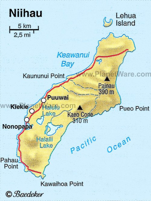
Third on the list is labeled as "Hawaii on the Web." This is another great place to learn about Hawaii. However, this website also includes some of the other surrounding islands. It is interesting because if you click on an island, it gives you the map of where it is located and a brief description of what it is. It also gives you an option to see what fun activities you can do on the island as well as what beaches you should explore while visiting. Last, it enables you to click on any of the places given so you can learn more about them and gather more information.

Click here to visit the website.

Next on the list is called "Learn How the Hawaiian Islands are formed." This website is much different in that it allows kids to learn how the Hawaiian islands are formed. It is very fun for children because is shows you pictures of each step of the process. They are pictures that can be easily understood by the children with a brief description of what is happening below it. It is a very fun and easy website to learn about how the Islands were formed.

Click here to visit the website.

The last website on the list is entitled "Virtually Hawaii." This is another virtual field trip of Hawaii but presented in a different way than mine is. The website presents the viewer with six of the eight islands to choose from. After you choose one, you click on it and it gives you 2-6 choices of places to view from that island. They are mostly places people will visit on trips, but it is helpful in learning about the culture and what each place has to offer. The website provides you with lots of pictures and brief descriptions that allow you to understand more about the islands.

Click here to visit the website.

Here is a photo of the beautiful sunset in Hawaii.
Website: http://www.oahulasik.com/images/OL-Hawaii_Sunset.jpg

Wednesday, November 5, 2008

Citations

All Information Was Found on the Internet

"Hawaii." Wikipedia. 6 Nov. 2008. Wikipedia. 2 Nov. 2008 http://en.wikipedia.org/wiki/Hawaii

"Kahoolawe." Wikipedia . 27 Oct 2008. Wikipedia. 2 Nov 2008. http://en.wikipedia.org/wiki/Kahoolawe

"Niihau." Wikipedia . 27 Oct 2008. Wikipedia . 2 Nov 2008. http://en.wikipedia.org/wiki/Niihau

Kauai." Wikipedia . 5 Nov 2008. Wikipedia. 2 Nov 2008. http://en.wikipedia.org/wiki/Kauai

"Maui." Wikipedia. 29 Oct. 2008. Wikipedia. 2 Nov. 2008. http://en.wikipedia.org/wiki/Maui

"Oahu." Wikipedia. 4 Nov. 2008. Wikipedia. 2 Nov. 2008. http://en.wikipedia.org/wiki/Oahu

"Lanai." Wikipedia. 27 Oct. 2008. Wikipedia. 2 Nov. 2008. http://en.wikipedia.org/wiki/Lanai

"Molokai." Wikipedia . 2 Nov 2008. Wikipedia. 2 Nov 2008. http://en.wikipedia.org/wiki/Molokai


Picture Sources- In No Particular Order

My Blog: http://katesvirtualfieldtrip.blogspot.com/

Hawaiian Map: http://waikoloa-realty.com/wri-images/hawaii.gif

Hawaii Map: http://media.maps.com/magellan/Images/Hawaii%20island-W1.gif

Hawaii Sunset: http://encyclopedia.smokersclub.com/images/hawaii.jpg

Ocean Hawaii: http://www.adventure-travel.org.uk/img/hawaii_text.jpg

Oahu Map: http://www.williamloo.com/images/image001.jpg

Waikiki Beach in Oahu: http://media-2.web.britannica.com/eb-media/85/67385-004-B1A06FC9.jpg

Diamond Head in Oahu: http://www.oahuoceanactivities.com/diamond-head.jpg

Map of Maui: http://www.lonelyplanet.com/maps/north-america/usa/maui/map_of_maui.jpg

Lahaina in Maui: http://lh4.ggpht.com/_3U5FxdKTQsQ/RoaoHtjjzdI/AAAAAAAAAJE/MCalOaKOHCk/dcp_1502.jpg

Coast of Maui: http://www.hawaiiactive.com/img/act/MauiCharters601-3.jpg

Lanai Map: https://www.htyellowpages.com/lanai/big_lanai_map.gif

Shoreline Picture in Lanai: http://img.pixelsucht.de/hawaii/lanai-hulopoe-bay.jpg

Hotel Resort In Lanai: http://www.langkawi-beaches.com/image-files/the-lanai-langkawi.gif

Molokai Map: http://www.5starhawaiiresorts.com/images/molokai-hotels-map.jpg

Molokai Kamakou: http://lh4.ggpht.com/_wgvJ2nAzW7I/SAVNLUXBHdI/AAAAAAAAAy4/G17EQFzG_kA/IMG_2433.JPG

Fish Ponds- Molokai: http://www.magiccarpetjournals.com/hawaii/fishpond_s.jpg

Map of Kauai: http://www.hawaiirentalcondo.com/Large%20Pics/Maps_Kauai.jpg

The Spouting Horn of Kauai: http://baglady.dreamhosters.com/wp-content/uploads/2007/09/img_1968.JPG

North Shore of Kauai: http://www.kauai-beachfront.com/photos-906/beach2.jpg

Niihau Map: http://www.planetware.com/i/map/US/niihau-map.jpg

Niihau- Puuwai: http://media-2.web.britannica.com/eb-media/58/116358-004-1CEA396A.jpg

Dry Areas In Kahoolawe: http://www.northwesthawaiitimes.com/storyimages/Kahoolawe2RA.jpg

Kahoolawe Map: http://www.brouhaha.net/ohana/images/map.jpg


Monday, November 3, 2008

Introduction: Beautiful Hawaiian Islands

Hey Everyone! Today we are going to be traveling to the beautiful Hawaiian Islands. We are going to learn about eight of the most beautiful islands in Hawaii. We hope that by the end of this field trip you will be able to identify all eight islands by name as well as three or more facts about each of them. Some of them may include tourist attractions, weather, size of the island, or any other interesting thing you learned on this trip. At the end of the trip, a project will be assigned to the class. Each group will do a different Island and show what it is that they learned by presenting a poster to the class. To be fair about grading, each person will also submit an individual paper about an island that they choose that they thought was interesting. They will present data learned from researching and in turn, create results that can be given to the teacher. It should be a fun and enjoyable experience for both the teacher and the students. Until then, enjoy the virtual field trip. The islands presented today are as follows; Hawaii, Kahoolawe, Niihau, Molokai, Lanai, Maui, and Oahu. Hope you enjoy!

Gorgeous Hawaii

We are going to start with the “Big Island or Sandwich Island” called Hawaii. This island is one of the most popular places to visit in the United States because of its beautiful scenery. Hawaii is the biggest Island out of the eight and is 10,931 square miles long. Did you know that this state was the last one to be admitted into the Union on August 21, 1959? That means that this was the last and final state to become part of the United States. One of the most unique things about Hawaii is that it is the only state that is completely surrounded by water. Now, I think that is a pretty cool fact. Another fun and exciting thing about Hawaii is that the weather is so different from Oregon weather. They have what is called “tropical weather,” which means that it is hot, sunny, and somewhat humid most of the year. Unlike Oregon, which usually has four seasons, Hawaii tends to have only two; Summer and Winter. That’s pretty cool huh? Did you know that Hawaii’s capital is Honolulu? Well I bet you don’t know where it is located. It isn’t actually located in Hawaii. It is located in Oahu, which will be our next stop on our field trip to the Hawaiian Islands.

These beautiful pictures are of The map of Hawaii and two magnificent views to see when you visit Hawaii. The second photo, however is of beautiful Honolulu, the capital of Hawaii.

Incredible Kahoolawe

Kahoolawe is the most commonly forgotten island because it is the smallest of the eight islands. It is only a total 44.6 square miles long. However, the highest point is different in that it is a crater which is 1,477 feet high. (That is actually higher than Nihau’s highest peak). It is called Lua Makiki and is located on the top of Pu’u Moaulanui. As opposed to Kauai, which is the wettest island, Kahoolawe is one of the driest islands. This is due to the low elevation levels as well as being in the “rain shadow” of Maui’s 10,000 foot high Volcano. As of now, due to lack of resources, there are no current inhabitants living on the island. It is a gorgeous place, but isn’t developed enough for people to actually live on. It is a place to appreciate the natural beauty that we have been given. Now, on to the next location.

The first picture, located within the description, is of Lua Makiki in Kahlooawe. The second photo is another angle of Lua Makiki. The third is just the typical map of the island. The fourth is of the dry lands on the island. The fifth is of the beautiful parts of Kahoolawe.


Natural Niihau


Niihau is one of the islands people tend to forget about because it is the 7th smallest of the eight and is only 69. 5 square miles long. This is why it is nicknamed “the forbidden isle.” It does have a very important and unique feature about it. I bet you that you didn’t know that Niihau is the only island that has a natural lake. This lake is called Lake Halulu. This is also something that can be used in a paper. One of the most amazing things about this island compared to that of Maui or Hawaii is that it only contains about 160 people and all of whom are Native Hawaiians. They all primarily live on Puuwai and all speak Hawaiian. What is also very interesting about this culture is that the ukulele, guitar, and a cappella singer are very common music played and is seemed to be enjoyed by everyone who lives there. This island doesn’t have a lot of tourist attractions, but the history of the people as well as the 1,250 foot Mt. Paniau are worth seeing and learning about.


The first picture is of the island of Niihau and the second picture is of Puuwai, the city that is home to the most people. The picture above is of the island itself also known as the "forbidden isle." The third picture is of the people who live there. It gives you an idea of how they dress and what they look like as well as their traditions and an insight into their culture. The sign photo, located in Niihau, hopefully will give you more information on the island and its surroundings.

Fantastic Kauai


The island of Kauai is one of the wettest spots on the earth because it has an average rainfall per year of 460 inches. Wow, that is a lot of rain! Kauai is, however, the oldest of the main Hawaiian Islands and is fourth largest. It is 552.3 square miles and is the 21st largest island in the United States. Kauai has two very large mountain peaks both over 5000 feet tall. The tallest is called Kawaikini at 5,243 feet and the second is called Mount Wai’ale’ale at 5148 feet. Besides Kauai’s amazing geography, the island itself has a lot of fun and interesting things to do. On this field trip we will stop to look at some of the many tourist attractions in Kauai. Some of them may include The Spouting Horn, Princeville North Shore, Fern Grotto, and Ke’e Beach. Writing down facts and things you learned along the way will really help you in writing your final paper. The last and final stop on our journey will be Maui.

Pictures in order of their appearance: Kaua'i Map, Spouting Horn, Ke'e Beach, Fern Grotto, and the North Shore.